
�������: 1-15 ���鵽��֪ʶ�� ��ѧ Analysis����ؼ�¼2056�� . ��ѯʱ��(0.218 ��)
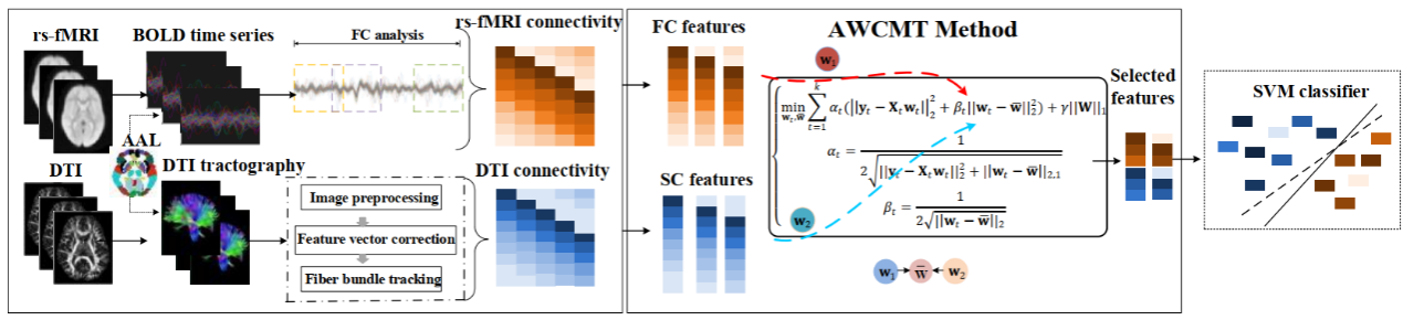
���ڣ����ڴ�ѧҽѧ������ҽѧ����ѧԺ���츻�����Ŷӵ��о��ɹ���Auto-weighted Centralised Multi-Task Learning via Integrating Functional and Structural Connectivity for Subjective Cognitive Decline Diagnosis���ڶ����ڿ�Medical Image Analys...
EVALUATING THE STRUCTURAL INTEGRITY OF THE SAINT ANTONIO BARREL VAULT IN THE FORTRESS OF ALMEIDA BY COMBINING LASER SCANNER AND LIMIT ANALYSIS
Historical construction Trace Italienne fortress Masonry Laser scanner Structural diagnosis Limit Analysis
2019/3/4
Under the framework of the modern theory of restoration, this paper shows the experimental results obtained during the structural diagnosis of one of the most important master gates inside the militar...
Discriminant analysis of colour measurements reveals allele dosage effect of ASIP/MC1R in bay horses
horse coat colour ASIP MC1R CIE L*a*b
2018/11/23
Considering the variability of bay coat colour, we aimed to investigate the association of different shades of bay with ASIP and MC1R genotype combinations and we studied the discrimination between th...
Genetic analysis of the Hungarian population of endangered Hucul horses
genetic diversity pedigree analysis genetic protection endangered breed
2018/11/23
The population genetic evaluation of the Hungarian Hucul horse population was performed based on pedigree records. Herd book data of registered Hucul horses available up to 2016 were analysed using EN...
POST PROCESSING AND ANALYSIS OF STORM SURGE: A CASE STUDY OF HUDHUD AND PHAILIN CYCLONES
Storm surge Mesh generation Post processing Inundation
2019/2/27
Tropical cyclones affect the east coast of India due to its distinctive topography which is formed with a network of estuaries, bays, rivers, and inlets that causes inland flooding. The inland inundat...
A COMPARATIVE ANALYSIS OF DROUGHT INDICES ON VEGETATION THROUGH REMOTE SENSING FOR LATUR REGION OF INDIA
Agriculture drought Vegetation Condition Index (VCI) Temperature Condition Index (TCI) Vegetation Health Index (VHI) drought assessment
2019/2/27
Drought intensifies stress on the water resource which is already in a critical condition due to rapid urbanization and population growth thus, affecting people, economy, and environment. The drought ...
IDENTIFICATION OF POTENTIAL SITES FOR WATER HARVESTING STRUCTURES USING GEOSPATIAL TECHNIQUES AND MULTI-CRITERIA DECISION ANALYSIS
Water harvesting structures Remote sensing and GIS Watershed management MSE AHP
2019/2/27
Changing hydrological phenomenon and increase the water demand in all sectors create a huge problem of water scarcity. Precipitation is one and only major source to mitigate this problem. In Central I...
PERFORMANCE ANALYSIS OF SISPELSAT MSK-DGNSS RADIO SIGNAL IN PENINSULAR MALAYSIA
Radio Beacon MSK SISPELSAT DGPS GPS GNSS
2018/11/8
The use of Global Navigation Satellite System (GNSS) has become essential in providing location based information and navigation. Due to low accuracy of navigation solution, differential technique suc...
MICROCLIMATE ANALYSIS OF DIFFERENT URBAN FORMS IN COLD CLIMATES AND THE EFFECT OF THERMAL COMFORT
Urban Microclimate Urban Geometry Outdoor Thermal Comfort Cold Climate Erzurum
2018/11/9
In this study, it is aimed to understand the relation between micro-climate and urban planning in the case of a cold-climate city, Erzurum. The effects of different urban patterns on micro-climate are...
INFORMATION CONTENT ANALYSIS FROM VERY HIGH RESOLUTION OPTICAL SPACE IMAGERY FOR UPDATING SPATIAL DATABASE
Information Content Topographing Mapping GIS Remote Sensing VHR Images
2018/11/9
High resolution satellite images started with IKONOS imagery. After the launch of the very high resolution IKONOS in the 1990s, a new generation of commercial Earth-imaging satellites have pioneered a...
SUPERPIXEL BASED FACTOR ANALYSIS AND TARGET TRANSFORMATION METHOD FOR MARTIAN MINERALS DETECTION
Superpixel Factor Analysis Target Transformation Minerals detection Mars
2018/5/15
The Factor analysis and target transformation (FATT) is an effective method to test for the presence of particular mineral on Martian surface. It has been used both in thermal infrared (Thermal Emissi...
ANALYSIS OF ACCURACY OF MODIS BRDF PRODUCT (MCD43 C6) BASED ON MISR LAND SURFACE BRF PRODUCT �C A CASE STUDY OF THE CENTRAL PART OF NORTHEAST ASIA
MODIS BRDF, model accuracy, MISR BRF, vegetation phenology, snow cover
2018/5/14
EOS/MODIS land surface Bi-directional Reflectance Distribution Function (BRDF) product (MCD43), with the latest version C6, is one of the most important operational BRDF products with global coverage....
EXAMINATION OF SPECTRAL TRANSFORMATIONS ON SPECTRAL MIXTURE ANALYSIS
Spectral Transformation Spectral Mixture Analysis NSMA BWVI Between-class Variance Within-class Variance Total-class Variance
2018/5/11
While many spectral transformation techniques have been applied on spectral mixture analysis (SMA), few study examined their necessity and applicability. This paper focused on exploring the difference...
HYPERSPECTRAL IMAGE DENOISING USING A NONLOCAL SPECTRAL SPATIAL PRINCIPAL COMPONENT ANALYSIS
Hyperspectral Images Noise Reduction Nonlocal Similarity Spectral Spatial Information Principal Component Analysis
2018/5/14
Hyperspectral images (HSIs) denoising is a critical research area in image processing duo to its importance in improving the quality of HSIs, which has a negative impact on object detection and classi...
SEMI AUTOMATED LAND COVER LAYER UPDATING PROCESS UTILIZING SPECTRAL ANALYSIS AND GIS DATA FUSION
NTDB (National Topographic Data Base), Segmentation, Classification, nDSM, data fusion
2018/5/11
Technological improvements made in recent years of mass data gathering and analyzing, influenced the traditional methods of updating and forming of the national topographic database. It has brought a ...
�й��о����������а�-��
- ���ڼ���...
�й�ѧ���ڿ����а�-��
- ���ڼ���...
�����ѧ���л������а�-��
- ���ڼ���...
�й���ѧ���а�-��
- ���ڼ���...
�ˡ���-ƪ
- ���ڼ���...
�Ρ���-ƪ
- ���ڼ���...
��������-ƪ
- ���ڼ���...
�������� -ƪ
- ���ڼ���...
֪ʶҪ��-ƪ
- ���ڼ���...
���ʶ�̬-ƪ
- ���ڼ���...
��������-ƪ
- ���ڼ���...
ѧ��ָ��-ƪ
- ���ڼ���...
ѧ��վ��-ƪ
- ���ڼ���...