搜索结果: 1-15 共查到“工学 Capacity”相关记录166条 . 查询时间(0.156 秒)

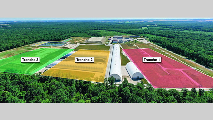
Application to raise capacity of French very-low-level waste repository(图)
法国 放射性废物处理 极低水平废物处置
2023/4/17

Grid reliability under climate change may require more power generation capacity(图)
Grid reliability climate change power generation capacity
2019/12/6
NSF-funded researchers are using a new modeling approach for infrastructure planning of a long-term electricity grid that considers future climate and water resource conditions. Those conditions incl...
EVALUATION OF RESOURCES CARRYING CAPACITY IN CHINA BASED ON REMOTE SENSING AND GIS
carrying capacity CCRR model modification remote sensing
2018/5/15
This paper accurately extracted the information of arable land, grassland (wetland), forest land, water area and construction land, based on 1 : 250000 basic geographic information data. I...
华南理工大学流体力学与传热课件chapter16-2 Capacity and economy of multiple-effect evaporators
华南理工大学 流体力学 传热 课件 chapter16-2 Capacity economy multiple-effect
2018/3/22
华南理工大学流体力学与传热课件chapter16-2 Capacity and economy of multiple-effect evaporators。
THE EXAMINATION OF GATHERING POINTS’ CAPACITY REGARDING MOBILITY AND ACCESSIBILITY: CASE OF BAYRAKLI DISTRICT
Disaster Social infrastructure areas Gathering points Accessibility Geographical Information Systems (GIS)
2018/4/18
The concept of accessibility that bases on continuing the flow of people, goods and services uninterruptedly is discussed as “maximum contact by minimum facility”. This concept which is related with t...
COMMUNITY-BASED NATIONWIDE CAPACITY BUILDING FOR GIS-BASED INTEGRATED FLOOD MANAGEMENT
Bangladesh integrated flood management (IFM) flood action risk information
2018/4/18
After the development of a flood action plan (FAP) in 1988, the Bangladesh government has led practical actions for nationwide flood management. However, Bangladesh is on its way to improve the capaci...
THE EXAMINATION OF GATHERING POINTS’ CAPACITY REGARDING MOBILITY AND ACCESSIBILITY: CASE OF BAYRAKLI DISTRICT
Disaster Social infrastructure areas Gathering points Accessibility Geographical Information Systems (GIS)
2018/5/8
The concept of accessibility that bases on continuing the flow of people, goods and services uninterruptedly is discussed as “maximum contact by minimum facility”. This concept which is related with t...
COMMUNITY-BASED NATIONWIDE CAPACITY BUILDING FOR GIS-BASED INTEGRATED FLOOD MANAGEMENT
Bangladesh integrated flood management (IFM) flood action risk information
2018/5/8
After the development of a flood action plan (FAP) in 1988, the Bangladesh government has led practical actions for nationwide flood management. However, Bangladesh is on its way to improve the capaci...
The UN Open GIS Initiative is to identify and develop, under UN guidance, an Open Source GIS bundle that meets the requirements of UN operations, taking full advantage of the expertise of mission part...
Dietary intake is independently associated with the maximal capacity for fat oxidation during exercise
health metabolism nutrition physical activity substrate oxidation
2018/11/13
Background: Substantial interindividual variability exists in the maximal rate of fat oxidation (MFO) during exercise with potential implications for metabolic health. Although the diet can affect the...
2017年充电储能高容量电极材料研讨会(Symposium ES2—High-Capacity Electrode Materials for Rechargeable Energy Storage)
2017 充电储能 高容量电极材料 研讨会
2017/2/16
High-performance rechargeable batteries are essential for a wide variety of applications including portable electronics, electric vehicles, grid-level energy storage, and defense purposes. To realize ...
第十届国际道路、铁路和机场承载能力会议(Tenth International Conference on the Bearing Capacity of Roads, Railways and Airfields)
第十届 国际 道路 铁路 机场 承载能力 会议
2017/1/19
BCRRA 2017 Conference will cover aspects related to materials, laboratory testing, design, construction, maintenance and management systems of transport infrastructure focusing on roads, railways and ...
A FRAMEWORK FOR CAPACITY BUILDING IN MAPPING COASTAL RESOURCES USING REMOTE SENSING IN THE PHILIPPINES
Coastal Resources Mapping LiDAR Remote Sensing Capacity Building Philippines
2016/11/15
Remote sensing has been an effective technology in mapping natural resources by reducing the costs and field data gathering time and bringing in timely information. With the launch of several earth ob...
RS-BASED WATER RESOURCES INVENTORY OF THE PHILIPPINES: CAPACITY BUILDING EFFORTS FOR NATIONWIDE IMPLEMENTATION
Capacity Building Hydrologic Data Geodatabase Water Resource Inventory Water Resource Mapping LIDAR
2016/11/15
Considering that the Philippines is archipelagic in nature and is exposed to disasters accentuated by climate change, water resource monitoring and management has been an important concern in the coun...


