搜索结果: 1-15 共查到“水文学 agricultural”相关记录41条 . 查询时间(0.14 秒)

兰州大学资源环境学院博士研究生田杰在Agricultural and Forest Meteorology 期刊发表研究成果(图)
兰州大学资源环境学院 博士研究生 田杰 高寒山区 土壤水文
2019/5/20
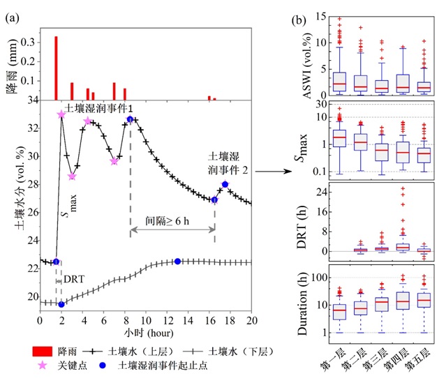
近日,兰州大学资源环境学院2015级博士研究生田杰和贺缠生教授与张宝庆教授(共同通讯作者)及合作者在国际一流期刊Agricultural and Forest Meteorology发表了题为“Dynamic response patterns of profile soil moisture wetting events under different land covers in the Mo...
An interface of drainage division for modeling wetlands and riparian buffers in agricultural watersheds
Drainage division DEM Geographic Information System GIS wetlands riparian buffers concentrated flow
2015/8/13
In a complex watershed, isolated wetlands, riparian wetlands and riparian buffers provide important functions such as flood attenuation and water quality improvement. For conservation purposes, it is ...
Assessment of the Impact pf Mining on Agricultural Land using Erosion-Deposition Model and Space Borne Multispectral Data
Mining Agricultural Land Erosion-Deposition Model Space Borne Multispectral Data
2015/8/6
Since erosion of mine overburden and mine dump leads to its deposition down the slope in the catchment, an attempt was made to study the erosion-deposition pattern in a micro watershed in part of Goa ...
Prioritizing Vegetative Buffer Strip Placement in an Agricultural Watershed
AGNPS Buffer Strips Sediment Geographic Information System GIS
2015/8/6
In this study, the Agricultural Nonpoint Source Pollution Model (AGNPS) was used to determine locations of vegetative buffer strip effectiveness on reducing sediment load within the East Bad Creek (EB...
Estimating sediment yield using Agricultural Non-Point Sources (AGNPS) model: The effects of slope information from different GIS softwares
Geographical Information System GIS slope information Sediment yield AGNPS model tropical catchment
2015/8/6
This study compares the effects of slope information derived from three GIS software on sediment yield as estimated using AGNPS model. The three GIS software are IDRISI for Windows, ERDAS Imagine and ...
Effects of agricultural conservation practices on oxbow lake watersheds in the Mississippi River alluvial plain
limnology management systems evaluation area nutrients pesticides sediment water quality
2015/3/9
Agricultural lands are considered to be a major source of nonpoint source pollutants such as sediment, pesticides and nutrients in the United States. Conservation practices have been tested for their ...
Runoff formation in a tile-drained agricultural basin of the Harz Mountain Foreland, Northern Germany
hydrograph separation hydrological tracers isotopes dyes groundwater drain sampler
2015/2/4
By taking two different tile-drained agricultural basins with porous aquifers in the lowlands of northern Germany as examples, it is demonstrated with an integrated study approach that this type of ba...
Remote sensing & GIS applications for drainage detection and modeling in agricultural watersheds
Remote Sensing GIS
2015/1/16
The primary objective of this research involves mapping out and validating the existence of sub surface drainage tiles in a given cropland using Remote Sensing and GIS methodologies. The process is de...
Nitrous oxide emission from riparian buffers in agricultural landscapes of Indiana
Nitrous oxide riparian agriculture denitrification
2015/1/16
Riparian buffers have well documented capacity to remove nitrate (NO3-) from runoff and subsurface flow paths, but information on field-scale N2O emission from these buffers is lacking. This study mon...
NITROGEN AND PHOSPHORUS CYCLING IN MIDWESTERN AGRICULTURAL WETLANDS IN RESPONSE TO ALTERED HYDROLOGIC REGIMES
Wetland soil Midwest agriculture
2015/1/16
The transfer of nutrients from US Midwest croplands into surface waters causes eutrophication and a decline in water quality. Temporary retention of nutrient-rich runoff in constructed wetlands can he...
An interface of drainage division for modeling wetlands and riparian buffers in agricultural watersheds
Drainage division DEM Geographic Information System
2015/1/7
In a complex watershed, isolated wetlands, riparian wetlands and riparian buffers provide important functions such as flood attenuation and water quality improvement. For conservation purposes, it is ...
Estimating sediment yield using Agricultural Non-Point Sources (AGNPS) model: The effects of slope information from different GIS softwares
Geographical Information System GIS slope information Sediment yield AGNPS model tropical catchment
2015/1/4
This study compares the effects of slope information derived from three GIS software on sediment yield as estimated using AGNPS model. The three GIS software are IDRISI for Windows, ERDAS Imagine and ...
Prioritizing Vegetative Buffer Strip Placement in an Agricultural Watershed
AGNPS Buffer Strips Sediment Geographic Information System GIS
2015/1/4
In this study, the Agricultural Nonpoint Source Pollution Model (AGNPS) was used to determine locations of vegetative buffer strip effectiveness on reducing sediment load within the East Bad Creek (EB...
Assessment of the Impact pf Mining on Agricultural Land using Erosion-Deposition Model and Space Borne Multispectral Data
Erosion-Deposition Model Space Borne Multispectral Data
2015/1/4
Since erosion of mine overburden and mine dump leads to its deposition down the slope in the catchment, an attempt was made to study the erosion-deposition pattern in a micro watershed in part of Goa ...
Water and nutrient balances in a large tile-drained agricultural catchment: a distributed modeling study
Water nutrient tile-drained agricultural catchment
2010/12/22
This paper presents the development and implementation of a distributed model of coupled water nutrient processes, based on the representative elementary watershed (REW) approach, to the Upper Sangamo...

