搜索结果: 1-15 共查到“农学 SAR”相关记录16条 . 查询时间(0.953 秒)

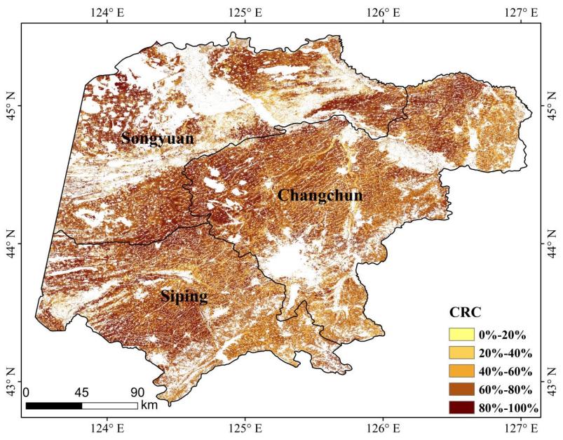
中国科学院东北地理所在SAR与光学影像协同监测保护性耕作方面取得重要进展(图)
光学影像 监测 土壤
2024/8/12
保护性耕作作为现代农业生产中对耕地最为重要的一种保护措施,在保护黑土地、提高和维持耕地质量以及改善区域生态环境等方面有着举足轻重的作用。秸秆覆盖在耕地表面能够减少风和水对土壤的侵蚀、增加土壤有机质的含量以及改善土壤的质量,减少黑土地的流失。秸秆覆盖度( crop residue cover,CRC) 是监测保护性耕作技术的关键指标,根据美国节能技术信息中心(Conservation Technol...
Integrating LiDAR, Multispectral and SAR Data to Estimate and Map Canopy Height in Tropical Forests
ALOS-PALSAR dry tropical forest Landsat-8 learning algorithms moist tropical forest Sentinel-1 spatial modelling
2024/1/22
Developing accurate methods to map vegetation structure in tropical forests is essential to protect their biodiversity and improve their carbon stock estimation. We integrated LIDAR (Light Detection a...
Forest Total and Component Above-Ground Biomass (AGB) Estimation through C- and L-band Polarimetric SAR Data
total and component biomass backscatter polarimetric SAR
2023/12/8
Forest biomass plays an essential role in forest carbon reservoir studies, biodiversity protection, forest management, and climate change mitigation actions. Synthetic Aperture Radar (SAR), especially...
SEA OIL SPILL DETECTION USING SELF-SIMILARITY PARAMETER OF POLARIMETRIC SAR DATA
Oil Spill Detection PolSAR Image Self-Similarity Parameter Polarimetric Features Look-alikes Remote Sensing
2018/5/15
The ocean oil spills cause serious damage to the marine ecosystem. Polarimetric Synthetic Aperture Radar (SAR) is an important mean for oil spill detections on sea surface. The major challenge is how ...
BACKSCATTER ANALYSIS USING MULTI-TEMPORAL SENTINEL-1 SAR DATA FOR CROP GROWTH OF MAIZE IN KONYA BASIN, TURKEY
Sentinel-1 backscatter SAR maize crop growth monitoring land use
2018/5/11
Temporal monitoring of crop types is essential for the sustainable management of agricultural activities on both national and global levels. As a practical and efficient tool, remote sensing is widely...
THE RESEARCH ON DRYLAND CROP CLASSIFICATION BASED ON THE FUSION OF SENTINEL-1A SAR AND OPTICAL IMAGES
Crop Classification Fusion Sentinel-1A Synthetic Aperture Radar Object-Oriented Technique
2018/5/15
In recent years, the quick upgrading and improvement of SAR sensors provide beneficial complements for the traditional optical remote sensing in the aspects of theory, technology and data. In this pap...
DETECTION OF LANDSLIDES WITH SAR POLARYMETRY: CASE STUDY OF SOUTH-EASTERN COLOMBIA
Backscattering Coefficient Dispersion Mechanism Landslides Polarimetry SAR (PolSAR) Entropy – Alpha Parameter Classification Principal Component Analysis
2018/4/18
SAR polarimetry (PolSAR) is a method that can be used to investigate landslides. Polarimetric scattering power decomposition allows to separate the total power received by the SAR antenna, which is di...
Detection of preparatory water in paddy irrigation area using RADARSAT/SAR-C and Landsat/ETM+
Remote Sensing Crop SAR Optical Accuracy Multitemporal
2015/7/29
Paddy rice is one of the most important crops in Japan and it needs much water to grow, especially for water reserves for paddy
irrigation. The test site “Owari Seibu” doesn’t have enough irrigation...
PRELIMINARY STUDY ON THE RADAR VEGETATION INDEX (RVI) APPLICATION TO ACTUAL PADDY FIELDS BY ALOS/PALSAR FULL-POLARIMETRY SAR DATA
SAR Radar Vegetation Index
2015/5/6
Kim and van Zyl (2001) proposed a kind of radar vegetation index (RVI). RVI = 4*min(λ1, λ2, λ3) / (λ1 + λ2 + λ3) They modified the equation as follows. (2009) RVI = 8 * σ0 hv / (σ0 hh + σ0 vv +...
RICE CROP MONITORING AND YIELD ESTIMATION THROUGH COSMO SKYMED AND TERRASAR-X: A SAR-BASED EXPERIENCE IN INDIA
Rice Food Security SAR
2015/5/6
Rice is the most important cereal crop governing food security in Asia. Reliable and regular information on the area under rice production is the basis of policy decisions related to imports, export...
星载高分辨率SAR土地利用调查监测应用潜力评价
星载高分辨率 SAR土地利用 调查监测应用 潜力评价
2011/9/29
近年发射的1 m/3 m高分辨率合成孔径雷达(Synthetic Aperture Radar,SAR)卫星为多云多雾地区土地利用动态遥感监测提供了重要数据源。为进一步检测高分辨率SAR卫星的适用性,采用对比分析和统计评价法,对TERRASAR、COSMO SkyMed、RADARSAT-2高分辨率SAR卫星中1 m聚束模式和3 m条带模式数据新增建设用地监测能力进行综合评价。结果表明,1 m聚束...
Synthesis, antifungal activity and SAR of N-substituted and N,N-disubstituted 2,4-dihydroxythiobenzamides
2,4-dihydroxythiobenzamides growth-inhibitory activity phytopathogenic fungi lipophilicity
2009/3/5
N-Substituted and N,N-disubstituted 2,4-dihydroxythiobenzamides were synthesized and their fungistatic properties were examined. The compounds were prepared by reacting sulfinyl-bis-(2,4-dihydroxyth...
热带人工林SAR散射组成及对遥感估测叶面积指数的影响
叶面积指数 后向散射系数 合成孔径雷达 RADARSAT
2009/1/19
基于RADARSAT SAR数据,利用MIMICS( Michigan Microwave Canopy Scattering)模型模拟森林组分(冠层、树干层、地表)雷达后向散射,模拟研究表明在稀疏的人工林地区,地表层与森林冠层的直接散射是影响森林总的后向散射中最重要的两个因素。在同样的地表条件与森林环境假设下,阔叶林的模拟结果与影像的一致性要优于针叶林,针叶林由于受到地形起伏的影响,难以利用模型...
热带人工林SAR散射组成及对遥感估测叶面积指数的影响
叶面积指数 后向散射系数 合成孔径雷达 RADARSAT
2009/1/19
基于RADARSAT SAR数据,利用MIMICS( Michigan Microwave Canopy Scattering)模型模拟森林组分(冠层、树干层、地表)雷达后向散射,模拟研究表明在稀疏的人工林地区,地表层与森林冠层的直接散射是影响森林总的后向散射中最重要的两个因素。在同样的地表条件与森林环境假设下,阔叶林的模拟结果与影像的一致性要优于针叶林,针叶林由于受到地形起伏的影响,难以利用模型...

