搜索结果: 1-15 共查到“工学 Three Dimensional”相关记录142条 . 查询时间(0.125 秒)
One-step self-assembly fabrication of three-dimensional copper oxide/graphene oxide aerogel composite material for supercapacitors
Graphene oxide aerogel CuO Supercapacitor Self-assembly
2023/6/21
A cylindrical composite material of three-dimensional copper oxide/graphene oxide aerogel (3DCuO/GOA) has been successfully synthesized as a supercapacitor electrode material by a convenient one-step ...
Academy of Mathematics and Systems Science, CAS Colloquia & Seminars:Fast and accurate solvers for the three dimensional elastic scattering problems
三维弹性 散射 求解器 弹性波
2023/4/26
A FRAMEWORK FOR RELIABLE THREE-DIMENSIONAL UNDERGROUND UTILITY MAPPING FOR URBAN PLANNING
Underground Utility Mapping 3D Mapping Urban Planning
2018/11/9
To optimise the use of limited available land, land-scarce cities such as Singapore are increasingly looking towards the underground in search of more space. A good understanding of what already exist...

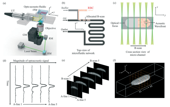
中国地质大学科学技术发展院宋潮龙等机电学院, Lab on a Chip, 27 March 2018. Opto-acousto-fluidic microscopy for three-dimensional label-free detection of droplets and cells in microchannels(图)
荧光剂;纳米颗粒;实现;物质;检测;分析
2021/10/21
2018年3月27日,微流控领域国际顶级期刊《Lab on a Chip》刊发了中国地质大学机电学院宋潮龙教授的最新研究成果:“Opto-acousto-fluidic microscopy for three-dimensional label-free detection of droplets and cells in microchannels”,该论文被推荐为封面文章。
QUALITY INSPECTION AND ANALYSIS OF THREE-DIMENSIONAL GEOGRAPHIC INFORMATION MODEL BASED ON OBLIQUE PHOTOGRAMMETRY
Oblique Photogrammetry Three-Dimensional Geographic Information Model Quality Inspection, Basic Principles Technical Features Common Problems
2018/5/11
In order to promote the construction of digital geo-spatial framework in China and accelerate the construction of informatization mapping system, three-dimensional geographic information model emerged...
A THREE-DIMENSIONAL AEROSOL VARIATIONAL DATA ASSIMILATION SYSTEM FOR AIRCRAFT AND SURFACE OBSERVATIONS
Data assimilation WRF/Chem Aerosol Aircraft
2018/5/16
A three-dimensional variational data assimilation system is implemented within the Weather Research and Forecasting/Chemistry model, and the control variables consist of eight species of the Model for...
THREE-DIMENSIONAL RECONSTRUCTION OF THE VIRTUAL PLANT BRANCHING STRUCTURE BASED ON TERRESTRIAL LIDAR TECHNOLOGIES AND L-SYSTEM
Terrestrial LiDAR L-system Branching structure Point cloud data Topology structure
2018/5/14
For the purpose of extracting productions of some specific branching plants effectively and realizing its 3D reconstruction, Terrestrial LiDAR data was used as extraction source of production, and a 3...
INTEGRATION OF THREE-DIMENSIONAL DIGITAL MODELS AND 3D GIS: THE DOCUMENTATION OF THE MEDIEVAL BURIALS OF AMITERNUM (L’AQUILA, ITALY)
3D GIS Documentation of Cultural Heritage Archaeological Heritage Digital Photogrammetry Archaeological Survey 3d modelling of archeological data
2018/6/5
This paper illustrates the results of an experimentation carried out by a multi-disciplinary research group made up of researchers from ITC-CNR of L'Aquila and of archaeologists of the University of L...
2018年SPIE三维和多维显微镜:图像采集和处理会议(SPIE Three-Dimensional and Multidimensional Microscopy: Image Acquisition and Processing XXV)
2018年 SPIE三维 多维显微镜 图像采集 处理 会议
2017/11/28
2018年SPIE三维和多维显微镜:图像采集和处理会议(SPIE Three-Dimensional and Multidimensional Microscopy: Image Acquisition and Processing XXV)。
ROBUST CYLINDER FITTING IN THREE-DIMENSIONAL POINT CLOUD DATA
Feature Extraction Geometric Shape Laser Scanning Object Recognition Pole Modelling Robust PCA Robust Regression Surface Fitting
2017/7/12
This paper investigates the problems of cylinder fitting in laser scanning three-dimensional Point Cloud Data (PCD). Most existing methods require full cylinder data, do not study the presence of outl...
2017数字全息与三维成像会议(The Digital Holography and Three-Dimensional Imaging meeting)
2017 数字全息与三维成像 会议
2017/4/25
The Digital Holography and Three-Dimensional Imaging meeting provides a forum for science, technology, and applications of digital holographic, and three-dimensional imaging and display methods. Topic...
COMPARISON OF COMMERCIAL STRUCTURE-FROM-MOTION PHOTOGRAMMETY SOFTWARE USED FOR UNDERWATER THREE-DIMENSIONAL MODELING OF CORAL REEF ENVIRONMENTS
Coral Reefs Coral Ecology Habitat Photogrammetry Structure-from-Motion Structural Complexity 3D topographic reconstruction 3D underwater modeling Agisoft Photoscan Pix4D
2017/4/5
Structural complexity in ecosystems creates an assortment of microhabitat types and has been shown to support greater diversity and abundance of associated organisms. The 3D structure of an environmen...
ACCURACY ASSESSMENT OF UNDERWATER PHOTOGRAMMETRIC THREE DIMENSIONAL MODELLING FOR CORAL REEFS
Photogrammetry Underwater 3D Modelling Accuracy Assessment Calibration Point Clouds Coral Reefs Coral Growth Moorea
2016/11/11
Recent advances in automation of photogrammetric 3D modelling software packages have stimulated interest in reconstructing highly accurate 3D object geometry in unconventional environments such as und...
THREE-DIMENSIONAL RECORDING OF BASTION MIDDLEBURG MONUMENT USING TERRESTRIAL LASER SCANNER
Three-dimensional Historical Monument Terrestrial Laser Scanning Time-off-flight Point Cloud
2016/11/11
This paper describes the use of terrestrial laser scanning for the full three-dimensional (3D) recording of historical monument, known as the Bastion Middleburg. The monument is located in Melaka, Mal...
RASTERIZATION AND VOXELIZATION OF TWO- AND THREE-DIMENSIONAL SPACE PARTITIONINGS
Vector-to-raster conversion voxelization 3D grid indoor model
2016/11/8
The paper presents a very straightforward and effective algorithm to convert a space partitioning, made up of polyhedral objects, into a 3D block of voxels, which is fully occupied, i.e. in which ever...


