搜索结果: 1-15 共查到“工学 2-DE”相关记录123条 . 查询时间(0.078 秒)
中华人民共和国科学技术部西班牙Odón de Buen号科考船下水
西班牙 海洋考察船 建造
2024/9/7
由西班牙高等科学研究理事会建造的Odón de Buen号科考船在维戈下水入洋,并计划于2024年年底前完成建造。Odón de Buen号科考船长84.3米,宽17.8米,建造成本约为8500万欧元,建造完成后将成为西班牙最大的海洋考察船,能够在包括极地在内的所有海洋中运行,最多可容纳58名乘客,同时允许39名科学家在船上开展研究。此外,这艘科考船还配备了可在深度超6000米海下工作的科研设备。

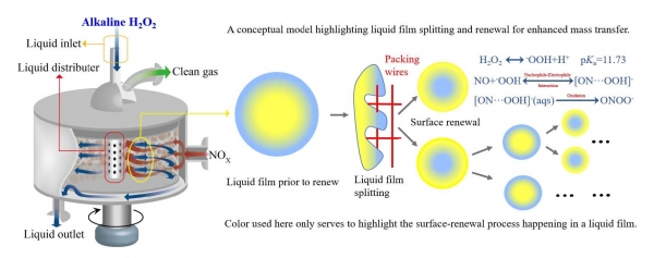
氮氧化物(NOx)污染是我国亟待解决的重大环境问题。NOx是形成光化学烟雾和雾霾二次颗粒物(PM2.5)的重要污染物和前驱体,其主要源于工业锅炉的高温燃烧。我国工业锅炉中有70%属于中小型锅炉,然而,应用于大型锅炉的成熟脱硝(De-NOx)技术——选择性催化还原烟气(SCR)干法脱硝技术,因其对中小型锅炉不具有成本效益而难以适用。因此,探索新型高效的烟气脱硝方法对于严格执行中小型锅炉达标排放、保障...

3D DATA PROCESSING TOWARD MAINTENANCE AND CONSERVATION. THE INTEGRATED DIGITAL DOCUMENTATION OF CASA DE VIDRO
3D Integrated Survey Documentation Point cloud processing and analysis
2019/3/1
During the last decade, 3D integrated surveys and BIM modelling procedures have greatly improved the overall knowledge on some Brazilian Modernist buildings. In this framework, the Casa de Vidro 3D su...
2017年12月9日上午,英国曼彻斯特大学Samuel P. de Visser教授来到我校访问,在物理南楼二楼学术报告厅作了题为《Elucidating the Regioselectivity of Substrate Activation by Nonheme Metal-Oxo/Peroxo Oxidants through Computational Modelling》的学术报告。物理...

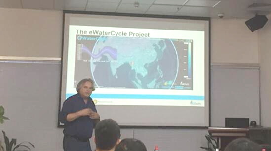
2017年11月6日上午11时,北京大学环境与能源学院“南燕科研论坛”系列讲座——“eWaterCycle Project Introduction ”学术报告在E-118会议室顺利举行。本次学术讲座邀请的演讲嘉宾是荷兰代尔夫特理工大学(Delft University of Technology)的Nick van de Giesen 教授,北京大学环境与能源学院秦华鹏、徐期勇、许楠等师生参...
VILLA STEIN-DE-MONZIE BY LE CORBUSIER (1926–1928): CONSERVATION STRATEGIES BETWEEN RESEARCH AND EDUCATION
Le Corbusier modern heritage conservation laser scanning photogrammetry
2017/6/20
The paper focuses on the educational experience produced during the International Workshop, organized by the IUAV University of Venice and dedicated to both the understanding and conservation of the m...
GEOTECHNOLOGIES FOR THE CHARACTERIZATION OF SPECIALTY COFFEE ENVIRONMENTS OF MANTIQUEIRA DE MINAS IN BRAZIL
Remote Sensing Coffee Environmental Characterization Geotechnology Geographic Indication
2016/11/30
Land-use/land-cover change (LUCC) is a major cause of environmental transformation. Distant drivers, often associated with emerging markets for specific products, are now being considered one of the m...
INTEGRATION OF IMAGES AND LIDAR POINT CLOUDS FOR BUILDING FA茿DE TEXTURING
Fa鏰de Texture GLCM Image
2016/7/8
This paper proposes a model-based method for texture mapping using close-range images and Lidar point clouds. Lidar point clouds are used to aid occlusion detection. For occluded areas, we compensate ...
DE-STRIPING FOR TDICCD REMOTE SENSING IMAGE BASED ON STATISTICAL FEATURES OF HISTOGRAM
Statistical Features of Histogram De-striping Histogrammic Centroid Correlation Coefficient Automatic Cloud Detection Non-uniformity
2016/7/4
Aim to striping noise brought by non-uniform response of remote sensing TDI CCD, a novel de-striping method based on statistical features of image histogram is put forward. By analysing the distributi...
A UNIVERSAL DE-NOISING ALGORITHM FOR GROUND-BASED LIDAR SIGNAL
Ground-based lidar Universal de-noising Signal segmentation Dual field-of-view Mie lidar
2016/7/4
Ground-based lidar, working as an effective remote sensing tool, plays an irreplaceable role in the study of atmosphere, since it has the ability to provide the atmospheric vertical profile. However, ...
De-Emphasis of Distracting Image Regions Using Texture Power Maps
Texture Power Maps Distracting
2016/5/24
We present a post-processing technique that selectively
reduces the salience of distracting regions in an image.
Computational models of attention predict that texture variation
influences bottom-u...
We present a semi-automated technique for selectively deanimating
video to remove the large-scale motions of one or more
objects so that other motions are easier to see. The user draws
strokes to i...
Digital Landscape Model DLM-DE - Deriving land cover information by integration of topographic reference data with remote sensing data
Digital Landscape Model Land Cover Mapping Semantic Transformation Interoperability
2016/1/25
Within the surrounding frameworks of the programme Global Monitoring for Environment and Security (GMES) (EEA, 2006) and
the Directive for the Infrastructure for Spatial Information in the European ...
Validation of CARTOSAT -1 DTM Generation for the Salon de Provence Test Site
Satellite remote sensing Digital elevation models Space photogrammetry
2015/11/24
Cartosat-1 is the eleventh satellite of the Indian Space Research Organisation series and is primarily meant for topographic mapping and Digital Terrain Model (DTM) generation. In the framework of the...


