搜索结果: 1-15 共查到“固体地球物理学 InSAR”相关记录44条 . 查询时间(0.062 秒)

精密测量院利用卫星InSAR开展四川泸定6.8级地震同震形变与冰川稳定性评估工作(图)
卫星 四川泸定 地震 评估
2023/11/6
2022年9月5日12时52分,四川省甘孜州泸定县发生6.8级地震,震源深度16千米,震中位于北纬29.59度,东经102.08度(中国地震台网正式测定)。本次地震及其诱发的大量山体滑坡以及可能的小范围冰崩等地质灾害,造成了重大人员伤亡及财产损失。

2022年1月8日青海门源6.9级地震InSAR同震形变场(图)
青海门源 6.9级地震 InSAR同震形变场
2023/1/16
联合升、降轨Sentinel-1A卫星的差分干涉数据反演2017年8月8日四川九寨沟MS7.0地震的断层滑动分布。首先对SAR复数干涉像对进行"二通"差分干涉处理,获取了覆盖震区的多视向InSAR同震形变场;然后利用四叉树和均匀采样法分别进行近、远场数据降采样,在此基础上,利用弹性半空间矩形位错模型,反演发震断层的几何参数和最优滑动分布。结果显示:①InSAR干涉条纹呈蝶状分布,最大LOS向沉降和...
ESTIMATION OF STATIC COULOMB STRESS CHANGE AND STRONG MOTION SIMULATION FOR JIUZHAIGOU 7.0 EARTHQUAKE BASE ON SENTINEL-1 INSAR DATA INVERSION
InSAR Coulomb Stress Change Slip Inversion Strong Motion Aftershocks Slip Model Jiuzhaigou Earthquake
2018/5/15
On August 8, 2017, an earthquake of M 7.0 occurred at Jiuzhaigou. Based on the Sentinel-1 satellite InSAR data, we obtained coseismic deformation field and inverted the source slip model. Result...
RESEARCH ON THE CRUSTAL DEFORMATION CHARACTERISTICS IN BEIJING USING INSAR AND GNSS TECHNOLOGY
Beijing INSAR GNSS Crustal Deformation Geological structure
2018/5/14
In this paper, we tried to reveal the characteristics of the crustal deformation in both the horizontal and vertical directions in Beijing using InSAR and GNSS observations. Regarding the serious land...
INTERSEISMIC DEFORMATION ACROSS THE EASTERN ALTYN TAGH FAULT FROM INSAR MEASUREMENTS
InSAR Altyn Tagh fault Interseismic deformation Slip rate
2018/5/15
As a new type of earth observation technique, InSAR has a lot of advantages, such as all-weather, all-time, high precision, high density, wide coverage and low cost. It has been widely used in deforma...
2017年8月8日我国四川九寨沟发生里氏7.0级地震.本研究利用基线校正方法获得距震中100 km范围内9个强震台站同震位移,基于Sentinel-1卫星干涉SAR影像对获取了InSAR同震形变场.结合GPS形变数据,本研究进行了震源滑动模型联合反演,结果显示此次地震整体以走滑运动为主,释放地震矩约为7.60×10¹⁸N·m(~MW6.52).通过对比模拟形变场和观测值显示,联合反演结果优于单独基...
2008、2009年柴达木盆地地震群InSAR分析及同震形变场反演
柴达木盆地 InSAR形变 滑动反演
2018/5/17
对发生在青藏高原东北缘-柴达木盆地北缘的4个中等震级地震分别做了研究,其中1个地震发生在2008年,另外3个发生在2009年。利用D-InSAR技术采用Envisat ASAR降轨数据获得了这4个地震的同震形变场。结果显示,2008年地震形变场只有1个形变中心,而2009年地震有3个形变中心。2008、2009年地震引起的卫星视线向最大形变分别为0.097m和0.41m。基于弹性半空间模型和InS...

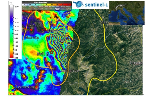
中国科学院测量与地球物理研究所利用Sentinel-1A卫星InSAR数据获取意大利佩鲁贾地震的同震干涉图(图)
中国科学院测量与地球物理研究所 Sentinel-1A卫星InSAR数据 意大利佩鲁贾地震 同震干涉图
2016/8/30
北京时间2016年8月24日9时36分(UTC: 2016-08-24 01:36:33),在意大利中部城市佩鲁贾附近发生Mw 6.2地震(42.714°N,13.172°E),震源深度10.0 km(USGS)。震后约1小时,于2016年8月24日10时33分翁布里亚大区(42.822°N 13.126°E)又发生Mw5.5地震,震源深度10.0 km(USGS)。意大利中部地区阿...
On the variations of InSAR-ICA altitudes in a mountain area of the Sele Valley (South Italy)
Synthetic Aperture Radar interferometry Independent Component Analysis ground deformations landslides subsidences
2015/8/28
The ERS-1/ERS-2 Synthetic Aperture Radar (SAR) data are processed by InSAR-ICA technique and the altitude variations are calculated for the period June-December 1995. For the same period and the same ...
Activation of the SIGRIS monitoring system for ground deformation mapping during the Emilia 2012 seismic sequence,using COSMO-SkyMed InSAR data
SAR interferometry Co-seismic displacement Earthquakes SIGRIS system Italy
2015/8/26
On May 20, 2012, at 02:03 UTC, a moderate earthquake of local magnitude, Ml 5.9 started a seismic sequence in the central Po Plain of northern Italy The mainshock occurred in an area where seismicity ...
The 2009 L’Aquila earthquake coseismic rupture: open issues and new insights from 3D finite element inversion of GPS, InSAR and strong motion data
GPS open issues and new insights
2015/8/17
We present a Finite Element inverse analysis of the static deformation
field for the Mw= 6.3, 2009 L’Aquila earthquake, in order to infer the rupture
slip distribution on the fault plane. An univoca...
The 2009 L’Aquila earthquake coseismic rupture: open issues and new insights from 3D finite element inversion of GPS, InSAR and strong motion data
Numerical approximations and analysis Seismicity and tectonics Dynamics and mechanics of faulting Europe
2015/8/14
We present a Finite Element inverse analysis of the static deformation field for the Mw= 6.3, 2009 L’Aquila earthquake, in order to infer the rupture slip distribution on the fault plane. An univocal ...
一种InSAR大气相位建模与估计方法
建模与估计 稳健估计 Matern模型
2015/7/27
为了削弱大气延迟对干涉结果的影响以提高InSAR的测量能力,本文在InSAR大气相位特征分析的基础上,研究了一种新的InSAR大气相位建模与估计方法.首先采用稳健估计确定大气垂直分层部分的模型参数,然后利用基于Matern模型的Kriging插值估计大气紊流部分,最后应用估计的大气垂直分层和紊流资料改正InSAR测量结果.利用覆盖河南义马地区的ASAR数据对本文提出的方法进行了验证,结果表明去除大...
2014年8月24日,在美国加州旧金山海湾北部的纳帕地区发生了MW6.1地震.发震断层是西纳帕断裂系统中的一部分,但是该断层之前并未被足够重视.本文利用欧洲空间局最近发射成功并刚刚投入使用的Sentinel-1A卫星获取的第一对同震干涉像对(20140807-20140831),得到了该地震的地表同震形变场,结合震后24 h内区域GPS同震形变资料作为约束条件,反演了纳帕地震的断层几何参数以及滑动...


